Place: Makira Island
Details
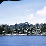
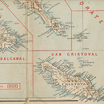
Makira Island is 3,090 square kilometres in size-139 long and 49 wide. Its mountainous spine reaches 1,040 metres elevation. The island is south of Malaita and Guadalcanal and situated on the division between Inner and Outer Oceania. Beyond it the Solomon Islands are much smaller and widely spaced, and a 350-kilometre ocean gap separates Makira from the Eastern Outer Solomon Islands.
The indigenous name for Makira is Hanuato'o, which translates as 'strong island'. Ulawans and Small Malaitans also used the name, as did sometimes the Anglican Church of Melanesia. (Fox 1978, 197; Ivens 1929, 90) Alvaro de y Neyra Mendaña (q.v.) in 1568 named the island San Cristobal, sometimes written as San Christoval or San Cristoval or Saint Christoval. Sixteenth-century Spanish expeditions recorded the local name for the southeast coast as Pouro (a name known as far away as the Duff Islands) and appear to have thought the north and south coasts were different islands since they called them two different names: San Cristobal and Santiago, respectively. There is evidence of a Spanish presence at Pamua on Makira, presumably from survivors of Mendaña's 1595 expedition. (Allen and Green 1972) Charles Woodford (q.v.) surmised from reports collected by Quiros in 1606 that Makira's south coast was known as 'Macaraylay' which presumably equates with 'Makira'. (Guppy 1887, 229; Woodford 1916, 40) That was used as the name for Makira Harbour as early as the 1840s and it came to label the whole island, probably between the 1930s and 1960s, when the district council became known as the Makira Council. The Marist Catholic missionaries in the 1840s knew the island as Arosi and the Anglican Melanesian Mission in the 1880s called it Bauro or Pouro, according to the mission the name of one group of people who live there. William T. Wawn, who sailed in the Queensland labour trade starting in 1875, called it San Cristoval (Wawn [1893], 1973), and Henry B. Guppy (q.v.), who visited the Solomons in 1882, called it Saint Christoval, but gave the local name as Pouro. (Guppy 1887, 100) Woodford referred to the island as San Christoval in the first BSIP Annual Report. (AR 1897-1898, 8) Rev. Charles Fox, who first went there in the 1900s, used San Cristoval. (Fox 1919) District Officer Dick Horton knew the island in the late 1930s and said the locals always knew it as Makira, although the Protectorate reports in that era still used San Cristoval. The Annual Report of 1974 still calls it San Cristobal, an indication that the change to Makira came after independence in 1978. (Horton 1965, 23; AR 1938, 3, AR 1974, 7; Scott 2007, 6; Michael Scott correspondence, 17 July 2011)
Makira can be grouped with Santa Ana, Santa Catalina, Ugi ni Masi (also just Ugi or Uki) and Ulawa, the peoples of which all speak closely related languages. Culturally and linguistically Ulawa is tied more to southern Malaita, Ugi lies somewhere in between, and Makira lies at the opposite end of the continuum. Santa Ana, Santa Catalina and Star Harbour, at the eastern end of Makira, form one focus and Arosi at the western end another. The latter has long had connections to Small Malaita and 'Are'are, Malaita, and to Marau Sound off eastern Guadalcanal. The areas also once used different stone tool kits; Ulawa and Malaita made adzes mainly from chert, whereas adzes from Makira and Santa Ana were of chert but also metamorphic rock. A trade network linked Makira/Ulawa to Marau Sound and to southern Malaita, with a few less-substantial links to the Eastern Outer Islands. (Green 1976, 13)
Onwards from the late 1840s, sheltered Makira Harbour became a favourite calling place for whaling (q.v.) ships, which were able to obtain fruit and vegetables, wood and water, and to trade for artefacts, shells and turtle shell. In return, the local people received iron goods and glass bottles, which they use to make sharp cutting edges. Visiting sailors also wanted local women for sex and could get them on Makira in return for gifts to the parents. Judith Bennett's research suggests that between 1850 and 1870 three whaling ships a year visited Makira Harbour, each staying for only a few days. Bennett notes that between the 1850s and the 1870s about thirty deserters from whaling ships lived on Makira, giving the people a level of early familiarity with outsiders not found on neighbouring islands such as Malaita and Guadalcanal. (Bennett 1987, 29-30, 41)
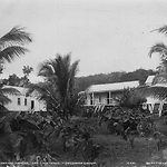
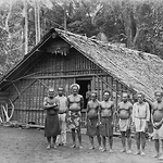
The Marists settled at Makira Harbour for twenty months in 1845-1847, but departed after some deaths from disease and violence. They chose Makira Harbour for its deep port but also because they had met a man named Loukou from the Mahia descent group, who had worked for some years as a cabin boy on an English ship and was willing to act as interpreter. (Wiltgen 1981, 330-346) A decade later Makira was accessed by the Anglican Melanesian Mission, which first took boys away as students in 1855 and established a permanent base at Wango, Makira in 1870, with Maurice Oha as teacher. Another base was opened soon after at Fagani, under Harper Mara. The first baptisms there occurred in 1875, and seven boys and one girl were sent to Norfolk Island for further education. By 1894, there were 135 Christians on Makira.
All of this development introduced trade goods and began to alter the pre-contact balance between descent groups. Makira men and some women were also major participants in the indentured labour trade to Queensland (807 between the 1870s and 1903), Fiji (681 between the 1870s and 1911) and internally in the Solomons (3,213 between 1913 and 1940). These figures may include Santa Ana, Santa Catalina, Three Sisters and Ugi Islands, and possibly also Ulawa. (Price and Baker 1976; Siegel 1985; Shlomowitz and Bedford 1988) The effect of this circular labour migration was an introduction of European manufactured goods and, particularly important in the nineteenth century, the introduction of guns, mainly Snider rifles which, as elsewhere in the Solomons, altered the power balance between descent groups and made some bigmen more powerful.
In the 1900s, the Anglicans began to lose their monopoly on Makiran Christianity, which was strongest along the northwest coast. The SSEM established a base at Risunga in Wanoni bay, and Marist Catholics visited Makira in 1906 and 1908, recruiting youths for their school at Rau Sua on Guadalcanal. The Catholics also profited from labourers returning from Fiji who had been baptised there, and the Marists established a mission station at Wanoni Bay in 1909. Priests and nuns were stationed there and in 1914 a girls' school was operating. A second Marist mission station opened in 1937 at Faumera in Star Harbour, lasting until 1941. A government station was established at Kirakira in 1918, and a small hospital was built there in the 1930s. The Anglican Melanesian Mission established important schools on Makira and neighbouring Ugi Island. In 1911 they began St. Michael's at Pamua on Makira. All Hallows' (q.v.), a boarding school for boys and the Mission's senior school, was established at Pawa on Ugi in 1922. All Hallows eventually became the best school in the Protectorate until eclipsed by King George VI School (q.v.), opened on Malaita in the 1950s. St. Barnabas' at Alangaula (q.v.) on Ugi started in 1936. As elsewhere, Anglicans and Catholics often maintained friendships despite their rivalry, but this did not flow over to the SSEM, which bitterly opposed Catholicism. (Laracy 1976, 46-47)
Frederick Campbell (q.v.) established the Kirakira station in 1918, with a strict regime for health and labour on the island. In 1919, he decided to become a planter and settled at Waimamura, extending his lands during the 1920s to Maru, Hawa, Wai'ai Bay and Waimasi, forming the largest plantation holdings on Makira. In the 1930s, some local copra was produced and Campbell introduced a co-operative marketing system that enabled local growers to sell copra to him to export. There was also fishing for trochus shell, which was sold to Chinese traders or local planters. Several local plantations were established aside from Campbell's, at Maalu, Maro'u, Boroni, Waimarae, Monogai, Wairaha, and Purimatarofa on Cape Surville. Other plantations operated at Sumoli Bay on Ulawa Island, Selwyn Bay on Ugi Island, Three Sisters Island, and Bio, a small island north of Ugi. Despite these developments, the advantages gained from early contacts with whalers largely evaporated and Makira's people had limited access to the modern economy. (Bennett 1987, 28; Golden 1993, 271-272, 305-307) The only real indigenous success story was Peter Waitasu (q.v.) at Ugi, who managed to build a successful trading business. (NS 1 July 1966, 12 July 1955)
In 1932 an Austrian anthropologist Hugo A. Bernatzik visited Makira and took many photographs and collected stories and artefacts. His most important publication is Sudsee (South Seas) (1934).
In regards to health, by the 1930s there had been good progress with yaws eradication and the Melanesian Mission on Ugi provided some limited medical care to supplement Kirakira's hospital. Kirakira government station had to be closed for a year in 1933 and again in 1936, due to the economic downturn. Makira was granted its own Local Government Council in 1953. (Bennett 1987, 28, 269-270, 403; Scott 2005, 2007, 2012)
Related entries
Published resources
Books
- Bennett, Judith A., Wealth of the Solomons: A History of a Pacific Archipelago, 1800-1978, University of Hawai'i Press, Honolulu, 1987. Details
- Bernatzik, Hugo A., Sudee, Deutsche Buch-Gemeinschaft, Berlin, 1934. Details
- Fox, Charles E., Arosi Dictionary, Pacific Linguistics, Series C, No. 57, Department of Linguistics, Research School of Pacific Studies, Australian National University, Canberra, 1978. Details
- Golden, Graeme A., The Early European Settlers of the Solomon Islands, Graeme A. Golden, Melbourne, 1993. Details
- Guppy, Henry B., The Solomon Islands: Their Geology, General Features, and Suitability for Colonization, Swan Sonnenschein, Lowrey and Company, London, 1887. Details
- Horton, Dick C., The Happy Isles: A Diary of the Solomons, Originally published: 1965, Heinemann, London, 1965. Details
- Laracy, Hugh M., Marists and Melanesians: A History of the Catholic Missions in the Solomon Islands, Australian National University Press, Canberra, 1976. Details
- Scott, Michael W., The Severed Snake: Matrilineages, Making Place, and a Melanesian Christianity in Southeast Solomon Islands, Carolina Academic Press, Durham, Nth. Carolina, 2007. Details
- Wiltgen, Ralph M., The Founding of the Roman Catholic Church in Oceania, 1825 to 1850, Australian National University Press, Canberra, 1981. Details
Book Sections
- Green, Roger C., 'An Introduction to the Southeast Solomons Culture History Programme', in R.C. Green;M.M. Cresswell (ed.), Southeast Solomon Islands Cultural History: A Preliminary Survey, vol. Bulletin 1, The Royal Society of New Zealand, Wellington, 1976, pp. 9-117. Details
Journal Articles
- Allen, J. and R. C. Green, 'Mendana 1595 and the Fate of the Lost 'Almiranta': An Archaeological Investigation', Journal of Pacific History, vol. 7, 1972, pp. 73-91. Details
- Fox, Charles E., 'Social Organization in San Cristoval, Solomon Islands', Journal of the Royal Anthropological Institute of Great Britain and Ireland, vol. 49, 1919, pp. 94-179. Details
- Ivens, Walter G., 'A Study of the Language of Marau Sound, Guadalcanal, Solomon Islands', School of Oriental Studies Bulletin, vol. 5, 1929, pp. 345-58. Details
- Price, Charles, and Baker, Elizabeth, 'Origins of Pacific Island Labourers in Queensland, 1863-1904: A Research Note', Journal of Pacific History, vol. 11, no. 1-2, 1976, pp. 106-121. Details
- Scott, Michael W., ''I Was Like Abraham': Notes on the Anthropology of Christianity from the Solomon Islands', Ethnos, vol. 70, no. 1, March, pp. 101-125. Details
- Shlomowitz, Ralph, and Bedford, Richard D., 'The Internal Labour Trade in New Hebrides and Solomon Islands, c 1900-1941', Journal de la Société des Océanistes, vol. 86, 1988, pp. 61-85. Details
- Siegel, Jeff, 'Origins of Pacific Island Labourers in Fiji', Journal of Pacific History, vol. 20, no. 2, 1985, pp. 42-54. Details
- Woodford, Charles M., 'On Some Little-Known Polynesian Settlements in the Neighbourhood of the Solomon Islands', Geographical Journal, vol. 48, no. 1, 1916, pp. 26-49. Details
Images
.png)
- Title
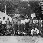
- A Group of Boys, San Cristoval (Makir) Island (Solomon Islands)
- Type
- Image
- Date
- 1906
- Source
- Anglican Church of Melanesia
- Title
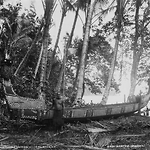
- A San Cristoval Canoe, San Cristoval (Makira) (Solomon Islands)
- Type
- Image
- Date
- 1906
- Source
- Anglican Church of Melanesia
- Title
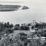
- An aerial photo of Kirakira government station, Makira Island, 1960s
- Type
- Image
- Date
- 1960s
- Source
- SIG
.png)
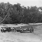
- Title
- Beach at Pamua-with Solomon Islands Canoe San Cristoval (Makira) (Solomon Group)
- Type
- Image
- Date
- 1906
- Source
- Anglican Church of Melanesia
- Title
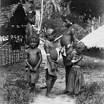
- Children of Fagani, San Cristoval (Makira) (Solomon Group)
- Type
- Image
- Date
- 1906
- Source
- Anglican Church of Melanesia
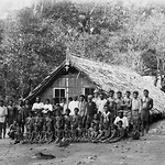
- Title
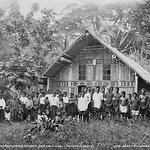
- Church and School People at Fagaui, San Cristoval (Makira) (Solomon Group)
- Type
- Image
- Date
- 1906
- Source
- Anglican Church of Melanesia
.png)
- Title
- Church and School People at Heuru, San Cristoval (Makira) (Solomon Islands)
- Type
- Image
- Date
- 1906
- Source
- Anglican Church of Melanesia
.png)
- Title
- Coast at Heuru, showing Fishing Stands, San Cristoval (Makira) (Solomon Islands)
- Type
- Image
- Date
- 1906
- Source
- Anglican Church of Melanesia
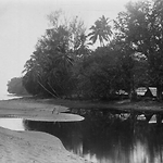
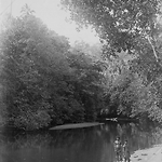
- Title
- Entrance, Wango River, San Cristoval (Makira) (Solomon Islands)
- Type
- Image
- Date
- 1906
- Source
- Anglican Church of Melanesia
.png)
- Title
- Gamal at Eteete, Ugi Island, Near San Cristoval (Makira) (Solomon Islands)
- Type
- Image
- Date
- 1906
- Source
- Anglican Church of Melanesia
- Title
- Gamal with Posts at Eteete, Ugi Island, near San Cristoval (Makira) (Solomon Islands)
- Type
- Image
- Date
- 1906
- Source
- Anglican Church of Melanesia
.png)
- Title
- Group of Girls at Heuru, San Cristoval (Makira) (Solomon Islands)
- Type
- Image
- Date
- 1906
- Source
- Anglican Church of Melanesia
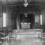
- Title
- Inside Church at Fagaui, San Cristoval (Makira) (Solomon Group)
- Type
- Image
- Date
- 1906
- Source
- Anglican Church of Melanesia
.png)
- Title
- Inside Church at Heuru, San Cristoval (Makira) (Solomon Islands)
- Type
- Image
- Date
- 1906
- Source
- Anglican Church of Melanesia
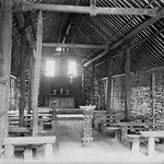
- Title
- Inside the Chapel at Pamua, San Cristoval (Makira) (Solomon Group)
- Type
- Image
- Date
- 1906
- Source
- Anglican Church of Melanesia
.png)
- Title
- Men at Heuru (Group 3, with canoe behind), San Cristoval (Makira) (Solomon Islands)
- Type
- Image
- Date
- 1906
- Source
- Anglican Church of Melanesia
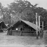
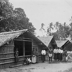
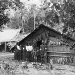
- Title
- Mission Station at Pamau, San Cristoval (Makira) (Solomon Group)
- Type
- Image
- Date
- 1906
- Source
- Anglican Church of Melanesia
- Title
- Old People at Heuru, San Cristoval (Makira) (Solomon Islands)
- Type
- Image
- Date
- 1906
- Source
- Anglican Church of Melanesia
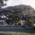
- Title
- Rain trees at Kirakira government station, Makira Island, 1971
- Type
- Image
- Date
- 1971
- Source
- Brian Taylor
- Title
- School House at Fagaui, San Cristoval (Makira) (Solomon Group)
- Type
- Image
- Date
- 1906
- Source
- Anglican Church of Melanesia
- Title
- School People at Eteete, Ugi Island (Solomon Group)
- Type
- Image
- Date
- 1906
- Source
- Anglican Church of Melanesia
- Title
- School People at Wango, San Cristoval (Makira) (Solomon Islands)
- Type
- Image
- Date
- 1906
- Source
- Anglican Church of Melanesia
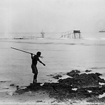
- Title
- Spearing Fish-Fishing Stands in the Background , San Cristoval (Makira) (Solomon Islands)
- Type
- Image
- Date
- 1906
- Source
- Anglican Church of Melanesia
.png)
- Title
- Taki, the Chief at Wango, San Cristoval (Makira) (Solomon Islands)
- Type
- Image
- Date
- 1906
- Source
- Anglican Church of Melanesia
- Title
- The Beach at Fagaui, San Cristoval (Makira) (Solomon Group)
- Type
- Image
- Date
- 1906
- Source
- Anglican Church of Melanesia
- Title
- The Wango River at Wango, San Cristoval (Makira) (Solomon Islands)
- Type
- Image
- Date
- 1906
- Source
- Anglican Church of Melanesia
- Title
- Three Generations A Family Group at Fagani, San Cristoval (Makira) (Solomon Islands)
- Type
- Image
- Date
- 1906
- Source
- Anglican Church of Melanesia